Tuesday, November 27, 2012

Post-Sandy Commute Survey

The NYU Rudin Center for Transportation Policy and Management release this survey regarding New Yorkers' ability to commute in the days after superstorm Sandy. I found a few of the findings to be particularly interesting:

  • Commutes were twice to three times as long, varying by location and mode
  • Walkers were the least frustrated, although walking was more difficult with commute times doubling for walk-only commutes.
  • Bicyclists were a close second in the frustration category, and the least delayed - reporting an average of 9 minutes additional commute time compared to normal.
  • Telecommuters (people who work at home) were actually more frustrated than bicyclists, as there were power outages and communications failures to contend with.
  • As you may expect based on damage - Staten Islanders were the most impacted, while Bronx residents were least affected.

Monday, November 26, 2012


WALKING IN BROOKLYN:

On the evening of October 27, 2012, I walked from my house to experience the use of bicycle throughout of my neighborhood. I took a walk along E 21st Street from E 21st Street and Beverley through Prospect Park to exit at E Lake Dr and Ocean Ave.From there, I went toward the intersection of Ocean Ave and Flatbush Ave.Then, I walked along Flatbush to get to my house. Here is the path of my trip (picture 1).
(Picture 1: Path of my trip)

When I got into the Park by the entrance of Ocean Ave and Parkside Ave, I found a well marking pavement. There are vehicle lanes, two-way bike path and two–way pedestrians’ path. Therefore, the safety is there (for more details, see picture below).
On my way to Ocean Ave and Flatbush from the intersection of E Lake Dr and Ocean Ave, I saw one man jump on his bicycle to ride in the direction of the traffic. Two minutes later; I saw a woman ride on the same direction as the man. It took me a couple minutes to watch them and analyze their path. So, to me, biking on shoulders of highway (Streets or Avenues) is 90% safe.


                (Picture 2: In Prospect Park)

From Ocean Ave and Flatbush Ave, I walked along Flatbush where I saw a man on his bicycle ready to cross the Avenue while a bus is passing. The man crossed through the intersection to the opposite direction of the vehicles. And then, he bikes on the pedestrian crosswalk (see picture 4).For me, biking in the opposite directions of the vehicles flow is not safe. The government should do something to prevent bicycle user from doing it.

                                                                                              (Picture 3 : Inside the Prospect park)


     (Picture 4: man on his bike ready to cross)


CITY OF CAHORS NEAR BORDEAUX (FRANCE):

In summer of 2004, I came to a City called “Cahors” to work.The place where I was working was located far away from the City. It was about 10 minutes in driving and 30 minutes in biking. To get to the City during my last couple months in this area, I used a bicycle that I borrowed from one of my cowokers.

My schedule at work was 5 days a week and 7 hours a day. I got break between 2pm and 7pm.As I like to read, I went everyday to the library of Cahors in the city in order to get a book or use internet to find out what’s going on through the world. Getting to the City have taken me a lot time between the time to get bus or vehicles from a bus stop and to reach the library or go back to my work site. Sometimes, I spent more than 3 hours waiting at the bus stop for going to the library.

One day; when I spoke to one of my coworkers about my daily commute to go the city, he felt sorry. And then, he decided to lend me his bike. It was a great bike( see the picture below that I took during this period of time). From the day I received it, it was easy for me to get to the library. As you can see in the map below, this was my path from the site of my work to the library.
My experience from biking during this summer:


First of the all, this two-wheeled adventure through rolling hills, mountains and valleys of the Cahors near “Bordeaux” improved my general health such as mental health and wellbeing. It also helps me with weight, stress management, fitness and saving money.


Secondly; from the day I got it until I left the place , I did by this bike all my daily commute, to and from the place where I lived and/or to somewhere in this small village. It helped me discover many historic sites, enjoy the scenic and get to the library any times I want.

Most of my trips, I shared the roadway with vehicles traffic. The only bad experience I have had is that I was riding uphill when an inter-regional bus was about 10 cm away to hit me. That was something unforgettable in my life. The problem is that there weren’t bike lanes on all over the roadways ( see the picture bellow that I took during this period of time).

Therefore, my positive experiences of biking are higher than the negatives.
                                                 On my way to the library

Sunday, November 25, 2012

Greenpoint-Williamsburg-LES-Chinatown-Downtown Bk-Bk Navy Yard-Williamsburg-Greenpoint

Greenpoint-Williamsburg-LES-Chinatown-Downtown Bk-Bk Navy Yard-Williamsburg-Greenpoint


Route Map
Riders: Chris Sedita, Craig Tarr, Olivia Vien
Length of route: 10.1 mi.
Time: 1.5 hrs
Ease of following route: easy
Type of bike lane: varied from dedicated, to shared, to no bike lane (see photos)
Perceived safety: generally very safe
Continuity of bike lanes: >90% (est.)


We started our ride on McGuinness Blvd and Huron St. in Greenpoint, Brooklyn.  The initial ride over to the bike route on Franklin St. contained no bike paths or lanes.  This particular part of Brooklyn doesn’t have traffic lights at every intersection, and it was quickly made clear that some drivers have little patience for cyclists with little room being given and a horn being utilized.

Once we reached Franklin St. and the bike route heading south, the ride became much more pleasant.  There was little traffic on the road, but when cars did pass it sometimes felt like there wasn’t a great deal of room.  However, once we reached Kent Ave. we reached a dedicated bike path, which was completely separated from the car traffic.  From here, it was a safe, relaxing ride down to the Williamsburg Bridge.

The entrance to the bridge itself is next to Continental Army Plaza, where pedestrians also have access to the bridge.  It was a little congested here and some cyclists dismounted to make it through the melee.  From here, we entered the path system to make the crossing.

Williamsburg Bridge, Manhattan side looking west: double bike lanes, two-way traffic, with pedestrian lane.
This path system is separated for most of the bridge, where the north side of the bridge is dedicated to bicyclists, and the south path is dedicated to pedestrians.  This is to keep both pedestrians and bicyclists safer by separating the two as well to accommodate more bike and pedestrian traffic.  The problem is that many pedestrians ignore this clear designation of paths and walk on the north side of the bridge dedicated for bicycle traffic.  This creates unsafe riding and walking conditions for everyone, as there is not much passing space especially during peak commuting hours.

Base of Williamsburg Bridge, Lower East Side.
At the bottom of this bridge, bicyclists are provided with paths that go in three directions: north, south, and east.  These bollards where placed at entry points for the bridge.  This restricts motorized vehicles from entering as well as encourages bicyclists to slow down as they either enter or exit the bridge.  Just a logistical complaint (or maybe we were just out of shape!) - the approach to the bridge is a fairly steep hill parallel to the bridge in the opposite direction, you are then forced to make a complete 180 and take the even steeper hill of the bridge deck from a near stop - great exercise, but a really tough ride for the uninitiated.

Chinatown: single one-way bike lane.
Upon reaching Chinatown, we encountered significant traffic.  Also, the bike lanes we encountered here (as shown above) are not as clearly marked as the painted green lanes found elsewhere.  These lanes are often found on narrower streets throughout the city.  The bicyclist is integrated into traffic alongside automobiles and pedestrians.  This part of the journey was a little tricky and unpredictable.  The rules of the road, and the determination as to who had the right of way, became somewhat vague.  The whole situation felt a little unsafe at times with the possibility of a car door opening suddenly or a pedestrian stepping out in front of you becoming very real.  Traffic was at a standstill at times, which actually made traversing the gridlock a safer prospect than when the traffic was moving, because cars were frequently firmly in the bike lanes.  
We made a quick stop before we made the trip back to Brooklyn.  We stopped at a store for refreshments, but found it difficult to find a safe or convenient place to lock up our bikes.  It was necessary to stack them up against a wall and to have someone wait with them.  This is probably a common problem around the city.  From here, we continued to the Manhattan Bridge.

Manhattan Bridge, Manhattan side looking east.  Double bike lanes, two-way traffic.
To our welcomed surprise, this bridge had a shallower slope compared to the Williamsburg Bridge!  There were also fewer pedestrians and cyclists in general, making it an altogether more pleasant ride in comparison.  Leaving the bridge and entering Dumbo we encountered an unusual stretch of roadway heading east on Sands St

Base of Manhattan Bridge, DUMBO. Double two-way bike lanes.

The unique aspect of this bikeway is that it acted as a separation between lanes accommodating two-way automobile traffic.  Unfortunately, there are very few of these in the city, it is a very safe way for cyclists to ride through heavily urbanized areas that incorporate highways.
Kent Avenue, Williamsburg/Greenpoint.  Double two-way bike lanes.
Once we reached Kent Ave. and the home stretch back to Greenpoint, we found ourselves on yet another type of bike lane.  These types of lanes are popping up more often throughout the city.  Street parking for automobiles are moved away from the curb and replaced by bike lanes.  This creates a buffer between automobile traffic and pedestrian/bike traffic.  However, automobiles turning left have a difficult time viewing bikers approaching intersections because the lane of parked cars can create a blind spot for drivers to see bicyclists.  Additionally, most pedestrians treat this lane as an expansion of the sidewalk and often walk out into the lanes without any awareness of oncoming bike traffic.

We arrived back in Greenpoint safely, and perhaps a little tired.  On looking at the time, we were surprised that we completed the route in such a short time.  A distance of approximately ten miles was covered in an hour and a half including a rest stop.  In addition, although the terrain was flat in most parts, some of the gradients we faced on the bridges were challenging at times.  On the whole, the experience was a positive one.

Interesting Articles

http://transportationnation.org/2012/10/07/data-nypd-confirm-evolution-of-police-tactics-for-cyclists-in-nyc/

http://www.bbc.co.uk/news/magazine-20068083

Sunday, November 18, 2012

Bicycle Lane at 1 Ave, between 59 and 75 Street


I walked by the bicycle path on 1st avenue, between 59th and 75th St, on November 4th, just after Hurricane Sandy hit Northeast.  The actual bicycle corridor starts at 60th street but there is a sign at 1st avenue and Greensboro Bridge that confuses people and it seems the path starts there.  The first thing I noticed was a bicyclist going the wrong way on 60th street towards 2nd Ave.  Also, I saw several cyclists going up on 1st avenue, endangering their lives since there is no dedicated bicycle way on that section.  

The bicycle passageway is highlighted in green and its purpose it’s clear.  The path is just beside the sidewalk, then there is a zebra mark and at the right -next to traffic, there's car parking; this parallel parking acts as a barrier and protects the bicyclists from oncoming traffic.  There are traffic signs at the intersections indicating there’s a bicycle road.  Throughout the path there are not enough bicycle parking spaces and people chain their bikes everywhere, any place seems to be valid.  I noticed the bicycle path is used by pedestrians, runners and cyclists.  Cyclists, delivering guys and just regular riders go either way; this can be explained since 1st avenue goes north and there is no bicycle path that goes south on the east side.   I guess they don’t want to risk riding south on 2nd ave where there is not devoted lane for bikes.  Bicyclists don’t respect traffic rules and since there is no law enforcement and NYPD is nowhere to be found on that avenue, they can do whatever they want.  The bicyclists even run red lights if there is not oncoming traffic, they seem not to be aware they need to respect the law and embrace the same rules as car drivers do.  I noticed two delivery guys in the way of oncoming traffic and they were using the space to chat disregarding any potential harm to them or other people. 

At 1st Avenue and 72nd St the bicycle path switches a few feet to the right, it’s not highlighted anymore and the traffic markings are faded.  The path situates itself just beside the ongoing traffic, the parallel car parking switches just next to the sidewalk, which means when a car needs to park has to temporarily occupy the bicycle path.  Taxicabs, delivery trucks, airport shuttles and others stop or park on the bicycle lane and cyclists need to pass them to the right endangering their lives with the oncoming traffic.  There is also a bicycle traffic signal at 1st avenue and 72nd St but it is not clear and goes unnoticed; bicyclists don’t notice it and cross the street without waiting for their turn; that traffic signal is wasted. 

The Upper East Side has the higher bicycle accidents rate in New York City; I can imagine during a regular weekday the path lane on 1st Ave must be more unsafe and disorderly than ever.  The intersection of 1st Ave and 68th St is the most dangerous since that’s the corner of Cornell-Columbia Presbyterian Hospital and it gets really crowded and convoluted during weekdays.  On the other hand, at other less crowded and friendlier bicyclist cities there are enough parking spaces (like Chicago, IL) and bicyclists seem to respect traffic laws (see the pictures); I have experienced that first hand, there is more peaceful relationship among pedestrians, bicyclists and vehicles.

Going the wrong way on 59 St 

1 Ave and 59 St

Pedestrians on the bicycle pathway


Not enough bicycle parking
At every intersection there is a traffic sign that shows there is a bike path


In the way of turning cars

Then, going the wrong way and not using the bike path
Bicyclist running a red light
Going the wrong way again...
Runners on the bike lane


Bike path switches to the right on 1 Ave and 72 St

Delivery trucks on the bicycle path


Fading traffic marks after 72nd St

Taxicab in the way of bicyclist

Airport shuttle parked on the bike path

Bicyclists in Washington DC respect traffic laws

Enough parking in Chicago, IL


Wednesday, November 7, 2012

Sandy Bike Bump Helped by NYC Bike Infrastructure by Sam Handler

Sandy Bike Bump Helped by NYC Bike Infrastructure

A week after Hurricane Sandy, a conversation about “hurricane-proofing” New York City has already begun. Storm barrierssubway tunnel plugsnew wetlands, and oysters are all on the table.
While that conversation must happen, it’s also important to recognize a piece of New York City infrastructure that has been essential in the aftermath of the storm (albeit powerless to keep the city dry): bike infrastructure. With repairs to the transit system ongoing, subway delays, and some service gaps, many New Yorkers have gotten their bikes out and ridden them through the gridlocked city. How many? 30,000 cyclists crossed the East River bridges last Thursday, according to NYCDOT. Normally, 13,000 do.
Without bike lane networks in the boroughs and without ways to safely pedal across the East River bridges, many New Yorkers would be having a much more difficult time getting back in motion after the storm.
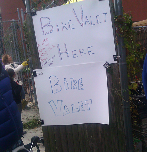
There were so many cyclists volunteering in Red Hook on Saturday that someone set up a free bike valet | Photo: TSTC
Imagine if there were no bike infrastructure on the Williamsburg Bridge. Would as many cyclists be riding to work across it? The same goes for the city’s pedestrian infrastructure. So even if bikes are “having a moment,” it’s important to recognize that that moment is only possible because people feel safer to ride or walk as a result of the infrastructure improvements made by the New York City Department of Transportation and the efforts of countless cycling and pedestrian advocates. But the progress can’t stop here. If the long lines of cars waiting for gas throughout the metropolitan region are any indication, greater transportation choice is needed to provide options for residents, not only in times of crisis, but in day-to-day life. Maybe it’s time to start thinking about that Verrazano Bridge bike lane and for the New York State Department of Transportation to get serious about implementing complete streets…