Wednesday, November 6, 2013

Williamsburg Bridge


New York City is an island, this is an understatement. The city is composed of 5 boroughs which include Manhattan Island, surround by busy, over populated neighborhoods in which most of the workforce reside. These individuals create the highest demand on transportation in the nation. Their options are: boat ferries, underground tunnels, sky trams, walking, biking and taking a motorized vehicle (taxi, private, bus, etc). Out of these, more than half are possible due to the bridges that connect this global city to the rest of the world.

Willaimsburg Bridge Peds and Bike Tracks Join

Besides the tolled motorized methods, which are a nightmare at rush hour, walking bridges is tedious, and doesn’t prove to be the most pleasant promenade. Most, if not every bridge connecting the Boroughs and New Jersey to Manhattan have dedicated bike lanes which include traffic control devices and are separated from motorized vehicles. All bridges differ in lane design, which is a bit upsetting once you are used to a daily commute and are forced to explore other alternatives. 

Brooklyn Bridge Narrow Bike and Ped Path
As an avid bicyclist, I’ve had the opportunity to travel on most of these bridges; including the Brooklyn, Manhattan, Williamsburg, Queensboro and George Washington, and other Bronx bridges.
Each experience has been unique in from safety, flow, traffic devices, lane width, end intersections and ramps. My daily commute consists of the Williamsburg Bridge onto East Broadway to the financial district.  The bridge is composed of four separate mode paths: motor vehicles, pedestrians, trains, and bicycles. While the train tracks remain in the centerline of the bridge, with the motorized lanes on its exterior, the pedestrian and bicycle paths are set above these. 
 
Williamburg bridge bike Only track
This is an excellent design due to that the noise level from the motor and tracks are somewhat buffed to the exposed individuals above. In addition the pedestrian track is on the southside of the bridge, totally separated from the bike tracks which differ from the Brooklyn bridge lanes where several accidents have occurred due to its narrow lanes. This The conditions of the lanes are good and have visible markings and warnings, the occasional chipping of the thin layer of asphalt that bikes require are treated annually. The width of the lanes is adequate for faster bikes to pass slower ones without creating any dangers for oncoming traffic. The slope of this bridge is not too dramatic as the ends were developed well inland on the Manhattan and Brooklyn sides, so this isn’t too much of a burden on cyclists. This differs from the Manhattan and Queensboro bridges which is drastically different in the ascending and descending slopes. 
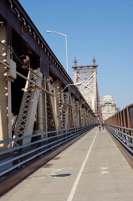
Queensboro Bridge Bike and peds lanes

Brookyln Bridge Ped and Bike paths


Finally, the intersections and access ramps towards and from the bridge dedicated lanes on the Williamsburg Bridge were clearly considered in the overall design. On the Manhattan side, the main intersection has various traffic signals and barriers informing motorized drivers of busy bicycle crossings while the green light time for bike and ped bridge access is decent and comfortable. On the Brooklyn side, the pedestrian and bicyclist tracks arrive at separate side of the bridges width and have quick access to the loop around under the bridge immediately after the exits. Compared to the other bridges, the Queensboro bridge lanes prove difficult to find as one must go around the block and towards the middle of the bridge foundation, one can finally access them. The Manhattan intersection for this bridge has been established the most dangerous intersections in the city where bicyclists have gotten hit. On the Brooklyn Bridge, the slope proves to be comfortable to such a point where the distance to the midpoint is twice as long, and finally the Manhattan Bridge does have safer access points, but like the 59h bridge, they are not symmetrical to the structures center line.
 
Williamsburg Bridge Brooklyn bike only access with illegal pedestrians
Williamsburg Bridge: Manhattan access

Tuesday, November 5, 2013

Learning to Bike in New York City

Because of this class, after my monthly metro card finished I decided to start biking. I already had a bike but I wasn't comfortable biking in the city yet. It was great that we started this bike blog because it gave me a reason to go out and give it a try.

Living on 121st and Morningside, getting to CCNY is a quick five minute trip and I had done it few times before but I wasn't prepared for what I was about to get into. My first trip was down to the Financial District. On google maps the trip is 8.6 miles with an estimated time of 46 minutes.


The majority of this route was on the Hudson River Greenway, which runs almost the entire length of the West Side of Manhattan. There are no bike lanes near my house that connect me the Hudson River Greenway so I took the most direct route possible north on Morningside avenue then west on 125th to the entrance by Fairway. This required navigating through a congested 125th street with speeding cars, freight trucks and public buses and going underneath the West Side Highway to get onto the greenway. After having done it a few times now it is not as bad but I could see how it could deter ridership. This is a major connectivity issue and greatly decreases the accessibility of the Hudson River Greenway.

Once I was on the Hudson River Greenway, I was cruising. Not only is it a smooth ride but its has a beautiful view of the city. The greenway appear to be used for commuting and recreation. The only bad thing about the greenway is that its next to the West Side highway but it does feel good when your biking faster than a car. I exited the greenway on Warren street toward Broadway where I made right then a left on Park Place at my destination. The Financial District has mostly one lane streets with low car traffic making it easy to navigate especially since its at the tip where Manhattan is at its densest. It would be interesting to see the Financial District converted into a google campus with citi bikes everywhere. On my way back I learned of the other bad thing about the greenway, the wind.

My next trip required me to go all the way down to St. Marks place in Greenwich Village. This trips I navigated my way south on Columbus avenue via a protected bike lane, from cars and the wind. First off, this route was much easier to get to than the greenway, Morningside avenue is not a bike lane but it has wide lanes and low car traffic, from there I headed west on 110th street then south on Columbus avenue.


The Columbus avenue bike lane starts off painted green with a buffer zone and parked cars between the bike lane and the cars. The path was well maintained with very little potholes allowing me to get up to speed on the first downhill only to be stopped by the traffic lights. I have since learned how not follow traffic signals but the first time out I learned how frustrating they can be as a biker. Biking is about momentum meaning it is easier to bike straight up a hill then to take breaks along the way. The rest of the trip I spent learning how to time the lights, read traffic and use my gears. 

Around 70th street the buffer goes away for a while and lane construction forced me to bike in traffic. Delivery trucks were also a common annoyance as they often park in the bike lane to make deliveries. At 66th street Columbus intersects with Broadway and drivers can go straight or left through the bike lane making that intersection unsafe. This intersection needs a bike traffic signal that allowed bikes to cross the intersection.

Once I was back downtown the streets were easy to navigate to my destination using multiple bike lanes and low traffic one way streets. On the way back I decided not follow a route. I started out downhill going north on an unprotected Third ave. With a yoga mat across my back it made it hard to check my rear but as I got used to the traffic I realized that its not that hard for bikes and cars to work together. Obviously still more dangerous for the biker but I found that car drivers were aware of bikers and tended to give them the right of way, especially taxis. From 59th street, I biked through Central Park to 110th street to Morningside avenue. The Central Park trail is not very flat making it more for the purposes of recreational biking. Still  a very fast uninterrupted ride.

Overall, I have been very pleased with my biking experience in New York. But there are tons of improvements that could be made. New York City unlike San Francisco is built for biking. It his high density, relatively flat due to road construction and thanks to the urban heat effect roads are usually clear in the winter.

I have now done both of these trips at least 10 times utilizing different routes and making up my own. I also bike to Washington Heights, its called the heights for a reason, and Randall's Island, which could use a bike bridge on 125th street. From this experience, I'm not afraid to bike anywhere in New York and am confident that I can match if not beat public transportation.


Monday, November 4, 2013

Brooklyn Community Board 1 – Williamsburg/Greenpoint has the highest bicycle commuter mode share in New York City according to screen line data.  The close proximity to Manhattan, abundance of safe bicycle facilities, and lack of multilane/high-speed roads contribute to make this area ideal for cycling. However, as Williamsburg has become a destination rather than just a bedroom community for Manhattan workers, the standard commute from Williamsburg to Manhattan is being met with atypical journeys. This is particularly true with commutes to and from Queens, which surrounds these communities on two sides.

Cyclists entering and exiting between Greenpoint and Queens in the north use the Pulaski Bridge, which has a narrow shared space for both cyclists and pedestrians. Due to heavy congestion and the narrow space, pedestrian and cyclist conflict is common. It would be a recommendation for NYC DOT to add bicycle facilities to the roadway, leaving the current space solely to pedestrians. However, research has indicated that the DOT Bicycle Program is currently conducting an engineering study to add protected bike lanes here. This leaves another principal route between Williamsburg and Queens at Ridgewood on Metropolitan Avenue.

On this corridor, the bicycle facility on Grand Avenue comes to an abrupt end at the Queens border. There is a significant amount of bicycle traffic on Metropolitan Avenue in Queens though it has considerable dangerous truck traffic as it is the only direct route to points east of Williamsburg into Queens. Fortunately, the most dangerous part of the corridor, determined by the number of trucks entering and exiting the thoroughfare, also has excess roadway width at 92 feet.  Adding a bicycle facility here could ameliorate the disconnected bicycle network between northern Brooklyn and Ridgewood/Middle Village. Traffic safety data indicates that this has been a very dangerous corridor for all street users.

Existing Conditions:
     Metropolitan Avenue at Varick Street, Queens

Proposed Design:
     164th Street between 65th Avenue and 67th Avenue, Queens

I personally use this route at least once a week to get from my home in Williamsburg to the Kissena Velodrome in Flushing, Queens during the summer. It should be noted that a large proportion of Kissena track racers, if not the majority, are also coming from north Brooklyn by bike along this route. Additionally, I have observed all varieties of cyclists, from delivery men to children, on this dangerous route.

I obtained crash data and analyzed it using the same methodology employed by the New York City Department of Transportation to calculate the severity of accidents per mile of roadway for the past few years (see tables).


Metropolitan Avenue - Grand Street to 69th Street, Queens
Safety Analysis
Route Length:
2.34
miles
Injury Summary, 2007-2011

Injuries


Total
Severe
Fatalities
KSI*
KSI - Killed or Severely Injured
Pedestrian
57
12
1
13

Injury Source: NYSDOT
Bicyclist
25
2
1
3

Motor Vehicle Occupant
421
28
2
30

Total
503
42
4
46

Fatality Summary, 01/01/2007-10/7/2013
Total
5
Fatality Source: NYPD
Pedestrian:
1
Bicyclist:
2
Motor Vehicle Occupant:
2
KSI/mile = 19.7

This KSI figure, at 19.7, represents a high crash corridor, putting it in the top 10% in KSI/mile in Queens during this period. Using NYC DOT’s bike map as a base, my proposed route is shown overlaid in purple, providing safe bicycle access to schools along Metropolitan Avenue and a safe and direct route to the Queens Greenway at Forest Park from Grand Avenue in Williamsburg. This route would expand the bicycle network and link fragmented portions of existing facilities. 


Bicycle Facilities for Penn Station and Port Authority Commuters

I daily commute by taking a bus from Summit, NJ to New York City. Actually, the park and ride station where the bus stops does not have a bike rack. So, they do not promote the use of bike. But that is another story.

As I take the bus from NJ to Port Authority and then take the MTA train to CCNY, I thought that would be nice to, instead of taking the train, bike to the school. So, I thought to give it a shot to the Citi Bike since there are a lot of stations around Port Authority. On my way to the city, around 6:40am, I downloaded the Citi Bike app and started to look for available bikes. For my surprise at 6:55am there were just 7 bikes available from 201 docks around Port Authority. At 6:58am, I looked a little farther and just 6 bikes were available from 164 docks around Penn Station.


I arrived at Port Authority around 7:10am and started walking to Broadway since the 42st and 8th Avenue was empty since I was in the bus. At Broadway & W 39 St., there was 0 bikes from 50 docks available according to the application. However, there were two bikes in the docks and according to the machine they were available to use. Also, I noticed that this station has a lot of space around it.


But walking a little farther to the south, I found this public space which I guess should be shared with bikers, because there was no bike line in the area but Citi bike stations, and it has a lot of tables and chairs.


Then, the 37th st and Broadway station was empty, too.


Just one broken bike.


Another station, 36th st and Broadway, was empty, too. Actually, the public space was dirty with a lot of trash with there were homeless people sit in the chairs. 


Everything got more interesting when I got into Herald Square. There were a lot of public spaces in the area and a bike line right next to the street. Also, a couple of police who, I guess are there for traffic but did not care about bikers.


There was a very interesting variety between people using helmet or not. In addition, others using the bike line or riding in the street.


The condition of the bike line was not pleasant to use and unsafe with a lot of stagnant water.


Other empty lots in the 33rd st and 6th Ave and 33rd and 7th Ave.


At least, I saw some people stopping at the red light.


Right next to the Penn Station (33rd and 7th Ave), there was a lot of people riding without helmet and against the traffic. Actually, there was a lot of traffic, noise and people walking around.


Finally, I walked into the train station to go to school around 7:50 am. I did not see people carrying helmets from NJ transit trains. My conclusion is that most of the people who come from NJ using the Penn Station trains or Port Authority buses and bike to their jobs do not carry helmets. Also, that there are a lot of people using the Citi Bikes. Interesting, most of the people I saw with helmets were using their own bikes. My suggestion is to increase the number of bikes in the stations because people that arrived to NYC around 7 to 8 am, which is the rush hour, are not able to rent any bike.