| |||||
Sandy Bike Bump Helped by NYC Bike Infrastructure
A week after Hurricane Sandy, a conversation about “hurricane-proofing” New York City has already begun. Storm barriers, subway tunnel plugs, new wetlands, and oysters are all on the table.
While that conversation must happen, it’s also important to recognize a piece of New York City infrastructure that has been essential in the aftermath of the storm (albeit powerless to keep the city dry): bike infrastructure. With repairs to the transit system ongoing, subway delays, and some service gaps, many New Yorkers have gotten their bikes out and ridden them through the gridlocked city. How many? 30,000 cyclists crossed the East River bridges last Thursday, according to NYCDOT. Normally, 13,000 do.
Without bike lane networks in the boroughs and without ways to safely pedal across the East River bridges, many New Yorkers would be having a much more difficult time getting back in motion after the storm.
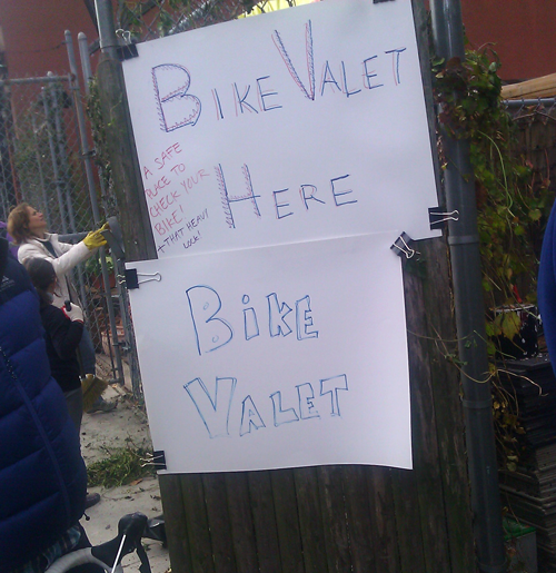
There were so many cyclists volunteering in Red Hook on Saturday that someone set up a free bike valet | Photo: TSTC
Imagine if there were no bike infrastructure on the Williamsburg Bridge. Would as many cyclists be riding to work across it? The same goes for the city’s pedestrian infrastructure. So even if bikes are “having a moment,” it’s important to recognize that that moment is only possible because people feel safer to ride or walk as a result of the infrastructure improvements made by the New York City Department of Transportation and the efforts of countless cycling and pedestrian advocates. But the progress can’t stop here. If the long lines of cars waiting for gas throughout the metropolitan region are any indication, greater transportation choice is needed to provide options for residents, not only in times of crisis, but in day-to-day life. Maybe it’s time to start thinking about that Verrazano Bridge bike lane and for the New York State Department of Transportation to get serious about implementing complete streets…
Article was taken from http://blog.tstc.org/2012/11/06/sandy-bike-bump-helped-by-nyc-bike-infrastructure/
| |||||
Wednesday, November 7, 2012
Sandy Bike Bump Helped by NYC Bike Infrastructure by Sam Handler


Friday, November 2, 2012
A mid-Brooklyn ride
 I’m a seasoned bike rider who uses my bike mostly for
shorter trips and the occasional longer recreational ride; however, I’m no
stranger to a long commute. Once I rode
by bike from Park Slope, Brooklyn through Manhattan to Englewood, NJ (without a
map); that was a 22 mile one-way commute and quite an adventure. As part of my ride for a Sustainable
Transportation course I planned a ride from my girlfriend’s house in the
Kensington neighborhood of Brooklyn (Dahill Rd at Ditmas Ave) to the Barclay’s
Center in Downtown Brooklyn using bike lanes as much as possible.
I’m a seasoned bike rider who uses my bike mostly for
shorter trips and the occasional longer recreational ride; however, I’m no
stranger to a long commute. Once I rode
by bike from Park Slope, Brooklyn through Manhattan to Englewood, NJ (without a
map); that was a 22 mile one-way commute and quite an adventure. As part of my ride for a Sustainable
Transportation course I planned a ride from my girlfriend’s house in the
Kensington neighborhood of Brooklyn (Dahill Rd at Ditmas Ave) to the Barclay’s
Center in Downtown Brooklyn using bike lanes as much as possible.  We were off to a good start with her having two flat tires
and my bike pump breaking half way through inflating the 2nd
tire. Expectedly (and no big deal) there
is no bike lane on her street so we rode along with regular traffic for about 8
blocks, where we each got cut off by consecutive turning cars, as we made our
way over to Ocean Pkwy that has a bike lane adjacent to the sidewalk, separated
from the street by a grass and tree lined buffer: safety finally. This lane is completely protected from
traffic but pedestrians often ignore the railing that separates the walking
from the biking traffic. In fact, there
was little or no signage that there were pedestrian and bike lanes until a few
blocks south of Church Ave. As we made
our way north towards Church Ave the bike lanes became better marked with
pavement
We were off to a good start with her having two flat tires
and my bike pump breaking half way through inflating the 2nd
tire. Expectedly (and no big deal) there
is no bike lane on her street so we rode along with regular traffic for about 8
blocks, where we each got cut off by consecutive turning cars, as we made our
way over to Ocean Pkwy that has a bike lane adjacent to the sidewalk, separated
from the street by a grass and tree lined buffer: safety finally. This lane is completely protected from
traffic but pedestrians often ignore the railing that separates the walking
from the biking traffic. In fact, there
was little or no signage that there were pedestrian and bike lanes until a few
blocks south of Church Ave. As we made
our way north towards Church Ave the bike lanes became better marked with
pavement markings through intersections and along the bike path.
 At the intersection of Church Ave where Ocean Pkwy becomes the Prospect
Expressway the bike lane has an interesting and well marked shift from the west
side of Ocean Pkwy to the service road that runs along the east side of the
Prospect Expressway. The pavement
markings are very visible and easy to understand, which made what I was expecting
to be a confusing intersection very simple to navigate. The bike lane continues on the sidewalk of
the service road then shifts onto the street with a 2 lane painted bike lane
just before the traffic circle at Coney Island Ave. Initially I wasn’t sure how the bike lane
navigated the circle, I was uncertain which direction to go, but I figured it
out pretty quickly. Turns out the bike
lane flows counterclockwise around the circle, just like the car traffic; who
thought common sense would prevail?
At the intersection of Church Ave where Ocean Pkwy becomes the Prospect
Expressway the bike lane has an interesting and well marked shift from the west
side of Ocean Pkwy to the service road that runs along the east side of the
Prospect Expressway. The pavement
markings are very visible and easy to understand, which made what I was expecting
to be a confusing intersection very simple to navigate. The bike lane continues on the sidewalk of
the service road then shifts onto the street with a 2 lane painted bike lane
just before the traffic circle at Coney Island Ave. Initially I wasn’t sure how the bike lane
navigated the circle, I was uncertain which direction to go, but I figured it
out pretty quickly. Turns out the bike
lane flows counterclockwise around the circle, just like the car traffic; who
thought common sense would prevail?
At this point we were going to enter Prospect Park where
there is no car traffic except during rush hour; however, due to damage from
Hurricane Sandy the park was closed and we were diverted onto regular streets
as there are no bike lanes heading north from this location. A parks police officer told us to bike up
Prospect Park SW which I believe used to have either a sharrow or bike lane,
but after repaving it was not reinstalled.
The street is wide with a wide parking lane so biking still seemed
pretty safe. I think this would be a
great spot for a bike lane or sharrow because the park’s bike lane runs south
and north bound bikers would have to go out of their way by using the Prospect
Park Drive’s bike lane to access Park Slope and all spots west of the park,
besides, the street is wide enough to handle the lane with removing parking or
driving lanes.

Once we reached the traffic circle at the top of Prospect
Park SW we were able to access the infamous 2 way protected bike lane on
Prospect Park West. This lane is very
well marked with paint and signs. There
are warning signs with flashing lights to tell bikers to yield to pedestrians
in the crosswalk. Additionally, there
are signs on the pavement and on poles informing pedestrians to look both ways
before stepping into the bike lane; however, I find they often forget to look. This is probably the biggest danger to bikers
and pedestrians regarding protected bike lanes adjacent to sidewalks.
 |
| Grand Army Plaza: the bike lane goes where? Who has right of way? This is a FAIL DOT |
Arriving at Grand Army Plaza we encountered an “interesting”
confluence of a pedestrian plaza with a busy two-way bike lane and no clear
right of way. This could be dangerous
because bikers may be cruising into the plaza as families with small children
are exiting Prospect Park through the plaza.
Once past this 25ft mess the protected bike lane continues through Grand
Army Plaza and over to Vanderbilt Ave.
We traveled down Vanderbilt where a car was conveniently parked in our
bike lane. We then turned on Bergen St,
which also has a bike lane and no geniuses
parked in it. We had smooth sailing
until the intersection of  Bergen St, 6th Ave and Flatbush Ave where
police cars parked in the bike lane forcing us into traffic. This was the only instance of police vehicles
blocking our bike lane; however, I experience it often during many other rides. I’m very glad that the NYPD takes biker safety
so seriously, thanks Big Blue.
Bergen St, 6th Ave and Flatbush Ave where
police cars parked in the bike lane forcing us into traffic. This was the only instance of police vehicles
blocking our bike lane; however, I experience it often during many other rides. I’m very glad that the NYPD takes biker safety
so seriously, thanks Big Blue.
 Bergen St, 6th Ave and Flatbush Ave where
police cars parked in the bike lane forcing us into traffic. This was the only instance of police vehicles
blocking our bike lane; however, I experience it often during many other rides. I’m very glad that the NYPD takes biker safety
so seriously, thanks Big Blue.
Bergen St, 6th Ave and Flatbush Ave where
police cars parked in the bike lane forcing us into traffic. This was the only instance of police vehicles
blocking our bike lane; however, I experience it often during many other rides. I’m very glad that the NYPD takes biker safety
so seriously, thanks Big Blue.
We continued on Bergen St and turned north on 5th
Ave which has a sharrow. After 2 blocks
we were at our destination, the Barclay’s Center. Bike parking was around back right off the
Dean Ave bike lane, we had to ask security where the bike parking was, no
signage for it L It was hard to estimate how many bikes could
be locked up back there but I’d guess over 500.
According to google maps the ride was 4.6 miles and should take 25 minutes,
which was about our estimated travel time subtracting stops to take pictures
and to chat with a friend we saw along the way.
Bumping into this friend is an example of how biking can allows ‘space’
for interpersonal interactions which improve social capital and a sense of
community: hooray for biking!
Thursday, November 1, 2012

Friday, October 12, 2012
Kensington to CCNY
I
would generally describe myself as an experienced urban cyclist. I’ve
spent the better part of the last decade bicycling as a primary means of
transportation in Seattle and Olympia, Washington. My recent move to
New York City has changed my habits significantly. The ease of use of
best public transit our nation has to offer, combined with the
intimidation of traffic and pedestrians has left my bike idle most days.
I was an experienced urban cyclist, but New York is a different animal entirely.
For
my first real cycling excursion I chose to simply commute to school
using the first route advised by Google Maps for cyclists. Using the
subway as a primary means of travel on a daily basis, I have little
understanding of how neighborhoods connect above ground or what roadways
would be best, so this would also be a test of Google’s suggestion. I
jotted down the directions on a piece of paper, placed it in my jacket
pocket for easy access, and intentionally decided not to use my phone
for directions but to rely primarily on road signage to guide the way.
My path would take me through Prospect Park, up Vanderbilt Avenue, over the
Manhattan Bridge, across Prince Street to West Side Bike Path. Here’s
the map and stats:
***********************October 11
Left at 10:45am - Arrived 12:30pm (1h 45min)
Total Distance: 16.5 miles
Average speed: 9 ½ mph
Trip Path:
View Larger Map
Separated lane:
70% (11.6 miles)
Bike lane or sharrow:
22% (3.6 miles)
Mixed with traffic:
8% (1.3 miles)
***********************
Throughout
the trip I was pleased and impressed by what I found. I referred to my
direction cheat sheet only once. Signs clearly guided the way most of
the time and the amount of separated bike path I encountered was delightfully
shocking. I had prepared for the worst and discovered I had little
reason to be worried. I shared these pathways with a steady stream
of bicyclists, which added to the feeling of road safety because a
consistent flow helps to ensure bikes are seen and given adequate space
on the roadway by other commuters. Much of my route was surrounded by
greenspace and views of trees and water while many of the most dangerous roadways
provided clearly marked pathways separated by barriers, curbs, or road
markings. Overall, the trip made me appreciate the city in an entirely
new way, helping me to understand the layout and the connections from
one part to another.
 |  |
| Just a few feet of separation make a huge difference | Two-way bike path separated by barriers from busy traffic |
 |  |
| Flying over the bridge | West Side Bike Path |
 |
| I can deal with 100 blocks of this view |
The
positive experiences of my trip far outweighed the negatives, but the
few uncomfortable moments were not be ignored. In total I shared the
roadway with car traffic for only 8% of the trip, but that fraction
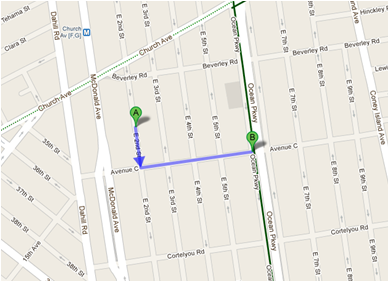
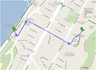
(depicted in the following three map screenshots) contained the only stressful
moments. Sharing the roadway means getting buzzed by cars and trucks
while constantly watching for opening doors and dodging pedestrians. These tend to be the slowest portions of the trip due to constant stoplights or stop signs, which some cyclists blow right past. For some unfortunate reason Google Maps instructed me to take a left on
Delancey Street as I crossed Manhattan. Bad move. These few blocks
were flat out awful, and I quickly became that crazy guy on the bike
between two giant, moving delivery trucks. Once I returned to the
safety of a bright green bike path on Prince Street I could breathe easy
again. The next step of bike planning for New York City concentrate on
these connection issues. I was astonished at the ease of navigation and
aesthetic enjoyment of my trip, but I can understand how these few
tricky intersections would be enough to deter less confident riders.
Bad intersections for bikers are usually just plain bad intersections
for everyone. By focusing attention to thoughtful multi-modal traffic
engineering on these trouble spots we can all benefit from a safe,
integrated bike network that separates bikes and cars, giving each the
space they need.

My
trip to school will not be something I intend to repeat with frequency, but this
is due to a simple matter of distance. Daily round-trip travels totaling 33
miles and nearly 4 hours are just not practical for me. If I were
employed in lower Manhattan I would absolutely consider it. Flying over
the East River on your bike is a remarkable way to start your day, and I
now know that by marking out a path I can commute to most places in the
city quickly and safely. I averaged 9.5 mph, which is a similar speed
to average Manhattan car trips. Unlike car trips, I will get the added bonuses of healthy
exercise, money savings, and the freedom afforded by urban bike travel. I'm happy to have taken this challenge and grown in my knowledge and appreciation for bicycle infrastructure in New York while overcoming my fears. Although my reverence for the sometimes maddening complexity of these streets will remain, I have a better understand of the niche that exists for bicycles.
-John Druelinger
-John Druelinger
Sunday, October 7, 2012
Staten Island bike-shopping trip
Route map:
 pic. 1 - route map
about 40% of the route
Shared with auto traffic:
about 60% of the route

 pic. 3 - Midland Ave. bike lane
Then I turned onto Hylan Boulevard, one of the busiest arterials on the island. This is when the horror started …Surprisingly, the pavement of this major road is much worse than that of the other streets. The right lane is designated for buses, no space for the bikes at all.
 pic. 4 - Hylan blvd.


pic. 6 - volume to be loaded pic. 7 - fully loaded "cargo" bike
It was harder to keep my balance riding a loaded bike than the unloaded one. With a few stops along the way to reset the bags, I finally arrived home. Surprisingly none of my stuff fell off or broke. Even eggs didn’t break despite the cracks and pits on the Hylan blvd. pavement and my sudden maneuvering on and off the sidewalk.
The return part of my journey that fell on Midland Avenue, was about the same pleasant and safe as the outgoing ride on same portion of the route.
From the fitness point of view, I learned that I lost about 200 calories during the trip , according to NutriStrategy website.
Unfortunately, it's not realistic as my average everyday trip is about 20-25 miles long , which can not made by the bike on a permanent basis.


versus:
pic. 8 - car takes half of driveway space pic.9 -little space needed for bike
Feliks Bogonovskiy

Dedicated bike lane:
about 40% of the route
Shared with auto traffic:
about 60% of the route
As usually, my wife gave me a shopping list of about 30
items.
I borrowed a special "shopping bike" from my neighbor and hit the road for the first time in the last 15 years.
Surprisingly the body automatically recalled childhood skills so I cycled away with a full faith in success of my bike adventure.
I borrowed a special "shopping bike" from my neighbor and hit the road for the first time in the last 15 years.
Surprisingly the body automatically recalled childhood skills so I cycled away with a full faith in success of my bike adventure.

pic. 2 - "cargo" bike
First , I went to Midland Avenue, which is the one of few streets on Staten Island that has got bike lanes. Though the lane is not physically separated by the barriers , it is distinctively marked by the signage and on the ground and is clearly visible by both auto drivers and bicyclists. Bike ride there is smooth and pleasant. Light traffic on the auto lane did not disturb me, I had a comfortably wide space for my bike. On the way I enjoyed nice views of the greenery , trees and neat houses on both sides of the road. No obstacles such as double parked or loading/unloading motor vehicles were observed on a bike lane in either direction. In fact, there is no need to park cars in double on Midland Ave. as there are enough spots for normal parking. The bike lane is well designed, the road surface is even, no large cracks, holes or parallel sewer grates on the way. This part of the route has got sufficient space for all traffic participants: motor vehicles, bikes and pedestrians on wide sidewalks. Thus there is no interference between the modes. Except watching out for possibly emerging autos turning to/from crossing streets onto Midland Ave. , I had no other worries.
First , I went to Midland Avenue, which is the one of few streets on Staten Island that has got bike lanes. Though the lane is not physically separated by the barriers , it is distinctively marked by the signage and on the ground and is clearly visible by both auto drivers and bicyclists. Bike ride there is smooth and pleasant. Light traffic on the auto lane did not disturb me, I had a comfortably wide space for my bike. On the way I enjoyed nice views of the greenery , trees and neat houses on both sides of the road. No obstacles such as double parked or loading/unloading motor vehicles were observed on a bike lane in either direction. In fact, there is no need to park cars in double on Midland Ave. as there are enough spots for normal parking. The bike lane is well designed, the road surface is even, no large cracks, holes or parallel sewer grates on the way. This part of the route has got sufficient space for all traffic participants: motor vehicles, bikes and pedestrians on wide sidewalks. Thus there is no interference between the modes. Except watching out for possibly emerging autos turning to/from crossing streets onto Midland Ave. , I had no other worries.

Then I turned onto Hylan Boulevard, one of the busiest arterials on the island. This is when the horror started …Surprisingly, the pavement of this major road is much worse than that of the other streets. The right lane is designated for buses, no space for the bikes at all.
The traffic was moderately congested; some cars were passing
by on my left side, just a few inches away. Pretty scary … With buses breathing
down my neck, I had no choice but to get over to the sidewalk. The space
between the right side of the bus and the curb was less than a foot wide (see
picture) with no space left for the bike to move in between.
Even though small part of Hylan boulevard (between Midland and Jefferson Ave.) is marked as having bike lane on the maps, in reality it means that bicyclists should use a bus lane. As stated above, sharing the road with buses may become an unpleasant experience.
Even though small part of Hylan boulevard (between Midland and Jefferson Ave.) is marked as having bike lane on the maps, in reality it means that bicyclists should use a bus lane. As stated above, sharing the road with buses may become an unpleasant experience.

When I reached Hylan shopping plaza, I faced another problem
as there are no facilities for bike parking. Finally I found some railing in
front of the Pathmark so I hooked the bike onto it and locked it. When I
entered the store, I was surprised to see that some people left their bikes in
the store lobby unchained and not locked

pic. 5 - bikes parked inside the store
After I was done with the shopping , I loaded the bike with the bags and cartons and started my journey home.
After I was done with the shopping , I loaded the bike with the bags and cartons and started my journey home.


pic. 6 - volume to be loaded pic. 7 - fully loaded "cargo" bike
It was harder to keep my balance riding a loaded bike than the unloaded one. With a few stops along the way to reset the bags, I finally arrived home. Surprisingly none of my stuff fell off or broke. Even eggs didn’t break despite the cracks and pits on the Hylan blvd. pavement and my sudden maneuvering on and off the sidewalk.
The return part of my journey that fell on Midland Avenue, was about the same pleasant and safe as the outgoing ride on same portion of the route.
From the fitness point of view, I learned that I lost about 200 calories during the trip , according to NutriStrategy website.
Rider profile:
-
Bike ownership – no ( borrowed from neighbor)
-
How often do use a bike? – first time for the last 15
years
-
Route length – about 4 miles total
-
Total trip time – 2 hours
-
Biking time – 25 min.
- Average speed - about 8mph
- Average speed - about 8mph
Route review:
-
Midland Ave.
portion: biking is easy and pleasant on dedicated bike lane
- Hylan Blvd. portion: biking is physically
challenging due to uneven pavement surface, not safe due to auto-traffic
interference.
Summary for bike-shopping: Using a bike for shopping could
be useful and safe on dedicated bike lanes only, for light shopping and compact
purchases.
Summary for biking in general:
Biking can be a primary means of transportation for the short distances, subject to
above mentioned conditions and favorable weather. I think the average person can physically do up to 5-7 miles of biking each way on everyday basis.Such physical exercise would be a healthy start and end of the work day.
Vehicle
size requirements comparison
A car
takes half of my driveway (see picture)
A bike
takes just a small area in the shed (see picture).
If I
get rid of my car and permanently switch from
driving to biking , I will get a lot of additional space for barbecuing :)
Unfortunately, it's not realistic as my average everyday trip is about 20-25 miles long , which can not made by the bike on a permanent basis.


versus:
pic. 8 - car takes half of driveway space pic.9 -little space needed for bike
Feliks Bogonovskiy
Subscribe to:
Posts (Atom)